Phase I
Resilient Connecticut Planning Framework - Phase I
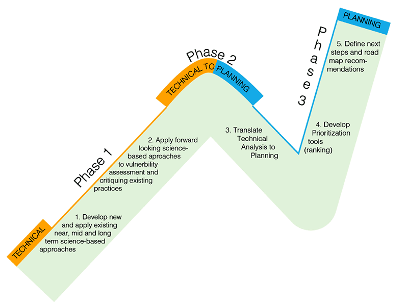
During Phase I of the project, the CIRCA team engaged a broad range of stakeholders on the development of a Resilient Connecticut Planning Framework. This Framework will guide the plans, projects, and research activities initiated during Phases II and III and will build on the range of ongoing climate adaptation activities occurring in the state. The Framework will connect science-based risk assessment with innovative design strategies and apply them to practical planning practices. The RCPF will introduce a variety of applied tools and methodologies intended to influence Connecticut's resilience planning moving forward, focusing on five themes.
Phase III
Phase III of Resilient Connecticut will develop location specific projects that build on Phase II Resilience Opportunity Areas (ROARS) with detailed analysis for implementation. Consultant teams are developing scientifically informed adaptation strategies and scoping the engineering and infrastructure components to 30% conceptual design for the seven projects below. For each project, feasibility and implementation strategies will be evaluated including historic and environmental permitting considerations, as well as a cost estimates, funding pathways, and coordination and alignment with Federal and State climate resilience programs.
 |
Ansonia: The resilient Ansonia project focuses on adapting to current and future climate induced flooding impacts in the downtown area and mitigating extreme heat impacts for residents. Descripción del Proyecto Ansonia |
 |
Branford: This project will address flooding from the Branford River, which occurs when the river (a tidally-influenced estuary) overtops its banks and water flows through an underpass serving a one-way street off Indian Neck Road at the railroad grade. Descripción del Proyecto Branford |
 |
Danbury: In addition to critical roadways and egress routes impacted by flooding, this project will assess future conditions and adaptation alternatives to mitigate flood and heat risks for critical facilities along Main Street, existing affordable housing complexes such as Danbury Commons, and private properties and future development. Descripción del Proyecto Danbury |
 |
Fair Haven: This project focuses on developing adaptation strategies to mitigate current and future climate induced flooding impacts to community assets and transportation corridors, as well as developing strategies to help mitigate the impacts of extreme heat for vulnerable community residents. Fair Haven Project Description Descripción del Proyecto Fair Haven |
 |
Fairfield: This project focuses on adapting to current and future climate induced flooding impacts to downtown Fairfield transportation routes where flood risk from storm surge and tidal flooding, extreme precipitation, and riverine flooding occurring simultaneously would present significant public safety challenges to residents, hinder the use of transit, and impair numerous small businesses. Descripción del Proyecto Fairfield |
 |
South Norwalk: This project focuses on mitigating the impacts of current and future climate induced flooding that impede access to lifelines and evauation routes from key neighborhoods and community assets as well as to help mitigate the impacts of extreme heat for the community. South Norwalk Project Description Descripción del Proyecto South Norwalk |
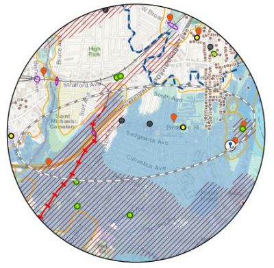 |
Stratford South End: This planning effort will: 1) focus on detailed review of the proposed South End and Employment Growth District's flood mitigation strategies from Stratford’s community resilience plan; 2) provide an assessment of ongoing implementation challenges; and 3) recommend updated or alternative strategies that can be developed as implementable projects to maximize the town’s resilience goals. Stratford South End Project Description Descripción del Proyecto Stratford Stratford South End Resilience Opportunity Area Map Portfolio |